Posts Tagged ‘dep’

Hanover Airport, Morris County

East Hanover Airport is located in Hanover NJ close to Route 280. It is located in what was the Glacial Lake Passaic. This was an area that was carved out by the last glaciers of the ice age that ended roughly 15,000 years ago. The area of Lincoln Park, Hanover, Chatham and the surrounding area floods frequently because of the low lying swamp land and the convergance of the Passaic and Pompton Rivers. The areas flooded badly several weeks and ago and 3 times in the last 4 years. the airport operated here from the mid 40’s until August 1985. The airport had been losing 10-15K a year and when a proposed office park fell thru, the airport closed for good. Thruout the 2000’s there were discussions of selling the 53 acres of land to the town or county and turning it into a park of some sort, perhaps funded thru the Green Acres fund. I came across a newspaper article in 2005 stating that this was the plan, but on a recent visit in 2011 it was clear that nothing has happened to date.

The airport originally had a 2,000 foot unpaved runway which eventually became a gravel runway and later a paved runway that ran northeast/southwest. At the southeast corner (where the nearby road bends sharply now) sat a hangar and some other office buildings. Despite the short runway, DC-3’s made an occasional landing there. The airport’s FAA license was not renewed in 1984 which sealed the fate of the little airport. The land is apparently still owned by the owner from 25 years ago, but there is no evidence that the property will be converted to a parkland any time soon. there is, in fact, evidence that there is some sort of contamination at the site. I don’t know anything more then what this sign says, so if anyone has a clue, please let me know.

All my flickr pictures can be found here.

Most of the information about the history of the hanover airport was found here a website which focuses on abandoned airports nationwide.

I have known about this place forever and had visited here in 2005. Not much has changed since then. Here is a picture of the office building from when the airport ewas open. Note the name of thew airport on the roof.

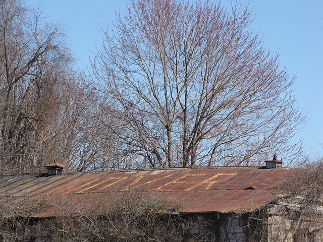
Today it looks a lot worse for wear.

http://farm6.static.flickr.com/5171/5572719580_cdf8af65a6_z.jpg

When I was inside the building snooping around the tin metal sheets of the roof were shaking and flapping, making for am very unnerving experience. When iI emerged I realized why it sounded so loud. A turkey vulture had been perched on the roof and flew off before I could take a picture. Inside the building I found the weirest grafitti, apparently outing a local resident who had been cheating his his spouse. Odd.

This compass was painted on the ground so it was visible from the air. This would help pilots orient themselves. In the second picture you can see the compass from the air.

The name of the airport was also painted in giant letters on the runway and are still legible after 3 decades.

middlesex beach shut down for next 5-10 years because of the lead contamination

and of course locals are ticked off

The Environmental Protection Agency is shutting down 1.3 square miles of coastal property, much of it along Raritan Bay, because dangerous levels of lead were found in the soil. EPA officials said they would post 4-by-4-foot, bilingual notices warning of the threat posed by contamination, and will install split-rail fences restricting access to the western jetty near Cheesequake Creek in Old Bridge, at a small beach north of the jetty in Sayre ville, at the Laurence Harbor sea wall in Old Bridge and at Marga ret’s Creek to the south.

“Our plan is to post signs — very aggressive signs, with strict language on it — explaining exactly what the threat is,” EPA project manager J. Daniel Harkay told about 100 people at the Old Bridge Environmental Commission meet ing on Wednesday night. The EPA said the signs will read: “Public health hazard/ Sand sediment and water contaminated with high levels of lead/ Access to the beach and sea wall located behind these signs is restricted/ No swimming/ No sunbathing/ No fishing.” The bills also note that expo sure to lead can be especially harmful to children and pregnant women.

The federal officials who spoke Wednesday said they did not know when, how or even if the sites would be cleaned up. Pressed again and again by angry residents who wanted a timeline for when some sort of re mediation might be done, Joseph D. Rotola, the agency’s regional Removal Action Branch chief, acknowledged that the sites could be closed for five to 10 years — maybe longer; he doesn’t really know. Pat Seppi, who will be the EPA’s public liaison, tried to calm the group. “Even working with the EPA, we get frustrated about the length of time,” Seppi said.

Right now, the agency is only in a position to close the areas, notify the public about the danger and continue to look into the extent of the contamination, according to spokeswoman Elizabeth Totman. “That’s why we’re investigating the scope of this,” she said yesterday. She said the agency does not have a time frame for when it might be considered for the Superfund list, which would make the site eligible for federal cleanup funds. She said there would be a better picture of what will take place in the next month or two. “We’re in the very preliminary stages on this,” said Totman.

Dozens of people spoke at Wednesday’s meeting. Some, like Rich Peterson, feared closing the sites for any length of time could spell disaster for Old Bridge and Sayreville, which have businesses that cater to fisherman and others who visit the no-swimming beaches. “I can’t see waiting around 10 years,” said the Elizabeth man, who fishes there. “People will organize. People will protest. … People will go bankrupt. People will have bad things happen in their lives.” The EPA reported the danger last month after receiving test re sults indicating very high levels of lead.

Rotola, the removal action chief, said Wednesday that residentially allowable amounts of lead measure 400 parts per million. At the western jetty near Cheesequake Creek, the highest levels found were 198,000 parts per million — nearly 500 times the residential limit and about 20 percent lead. The average in the area was 52,399 parts per million. The jetty’s size depends on the tide, but is about 755 feet long and 20 to 30 feet wide. At the Laurence Harbor sea wall area, the range of lead sampled was as high as 142,000 parts per million. The sea wall is about 2,345 feet long.

At the half-acre beach area in Sayreville, just north of the Cheesequake Creek jetty, the range of lead sampled was the same as at the jetty — as high as 142,000 parts per million. The Margaret’s Creek site, which is a remote location not frequented by people, is being added to the list at the state Department of Environmental Protection’s request. The DEP began testing wet lands in Old Bridge about two years ago when the township was looking to sell property, Ed Put nam, the DEP’s assistant director of the publicly funded remediation program, said last month.

A 1972 memo from National Lead Industries, which had a paint manufacturing facility in Old Bridge, indicates the company used the area to dispose of spent cases from acid/lead batteries. Because National Lead refused to help with the cleanup, the DEP turned the case over to the EPA in September, Putnam said. State health experts at Wednesday’s meeting said lead, built up in the blood stream over time, can cause brain damage, kidney failure, diminished intelligence and other issues. Children are much more at risk for absorbing lead than adults, as are pregnant women because of changed metabolism. The metal can be detected with blood tests.