I’ve done a fair amount of research on the NJ Palisades and I’ve visted all the ruins but I never knew much about the largest of the ruins in the park. This website not only runs down the history but has some awesome old pictures that show what it was like when it was in use. Well worth checking out.
Posts Tagged ‘NJ Palisades’
22 Mar
Devil Worshipping Grounds of Palisades Destroyed
I received an email telling me that someTHING (emphasis theirs) had destroyed the fence at the devil worshipping grounds. Also the site had been wrecked. I scoffed but when I got there I saw it was true…
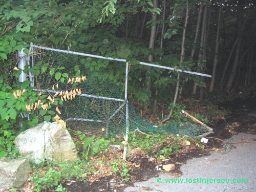


The email was correct. The entire site has been destroyed. The table top had been removed, the base destroyed (pieces and splinters), and the tv shattered. Whoever destroyed the gate was quite determined. At the time, nobody knew about this place. I hadn’t told anybody, & hadn’t posted in my journal or in my forums. It hadn’t yet been mentioned in the weird nj forums either. I don’t know when exactly the destruction occured, but something seems weird about it. The gate is 10 feet from the road, and there is really no feasable way to accelerate hard and ram the gate. I can’t picture anything short of a humvee other large SUV doing this.
What I want to know is why? Whoever destroyed the gate would have done considerable damage to their vehicle. I found pieces of headlight, and a lamp like you find on the top of jeeps and Humvees. Why damage an expensive vehicle like that? I can’t say if this is real satanists or not, but if it isn’t, someone went to a lot of trouble to convince folks that it is…. On a subsequent visit I saw that a chain was put across the entrance.
22 Mar
The Devil Worshippers of the NJ Palisades
In summer 2004 I received emails from 4 different individuals telling me that they had seen figures in robes dancing in the woods of the NJ palisades. They gave me the specific location, and told me that they had only seen these robed figures at night. Late at night. I identified the location easily on a map, and checked it out. I found all the things they said I would find, including a strange doll made out of duct tape, a tv with strange symbols on it, and a table with a pentagram on it.
The devil worship grounds are located in the Palisades, near the NY state border. There are no houses, no businesses and no place to park for nearly a mile. The woods where they are located are part of a tract of undeveloped land 1 mile wide and 3 miles long. It borders a Boy Scout Camp so there are dozens of trails. It appears part of the land is public, but the part where the devil worshipping occurs is private property. The owner is interested in building large mansions, but the obstacle is getting power, cable and phone lines brought out, as well as connected to the local sewer line.


I was convinced that someone was doing something in the woods here, but who and what? And why? Clearly someone put these things here. Is it a real satanic worship/cult activity? Or is it kids playing around? I have seen evidence of Wicca activity in these woods, but not satanic activity. I asked if the police had heard any reports of strange activity and they said no, but the officer made the odd statement that he would think it was real rather then kids because it was so far from anything that no kids would likely be bothered to go to the trouble to get to that spot. Not sure I agree or not…
22 Mar
Hamilton Death Rock
Alexander Hamilton & Aaron burr were enemies politically and personally. In 1791, Burr took a Senate seat from Philip Schuyler, Hamilton’s powerful father-in-law. Schuyler was a powerful ally for him as secretary of the Treasury. Burr ran for the governor of New York in 1804 as an independent. Hamilton helped to convince New York Federalists not to support Burr. The Burr campaign failed, and he was defeated soundly.
In 1804, Burr challenged Hamilton to a duel. After aids tried to settle their differently amicably, the two met on the dueling grounds at Weehawken, New Jersey on the morning of July 11. Each fired once. Burr struck Hamilton who died the next day. Hamilton’s shot missed. Burr was indicted for murder in New York State, but never prosecuted. After completing his duties as Vice President in 1805, Burr entered into a conspiracy to wrest the lands west of the Mississippi River from Spain; these intrigues included the Louisiana Purchase. The rock where Hamilton laid his head was preserved. Eventually it was moved to become part of a monument atop the cliffs of Weehawken. The duel took place below the cliffs.
7 Mar
The grave of Whack me Jug, with bonus graveyard orbs
Related Pages:
My experience in the NJ Palisades
Manuel Rionda’s Stone Tower: A large medieval looking tower which was part of an estate that stretched to the edge of the Palisades Cliffs
Old Bridge: In the woods of Creskill is a large stone bridge, which may be a part of the old Camp Merritt. A bit of research and a few emails from readers suggests this bridge is more likely a relic from the Rionda estate…..
There are tunnels and underground chambers in various places thruout the Palisades.
Hitler’s Rock Profile: A 160 ft tall profile of Hitler appeared on the cliffs of the Palisades during WWII
Complete history of the Palisades: A detailed summary of the history of the Palisades.
The Palisades is one of the first areas the Dutch settled when the colonized America. This cemetery (known as Undercliff Cemetery) is almost all that remains of the “Undercliff” families, a group of hardworking men & women who fished, quarried and eeked out an existence here in the early 19th century. The cemetery has 17 graves, 5 of which have headstones legible enough to read. One of the grave belongs to Julia Bloomer, whose family was so influential that the local beach was known as Bloomers Beach. Also buried here is Jimmy Cunningham, AKA Whack me Jug. When the quarrying outraged enough people that there was an effort made to preserve the park, there were only 2 families still living down by the water: the Van Wagoners & the Crums. They eventually sold out, and all that remains now is this cemetery. Apparently the cemetery was much larger at one point but many of the graves can no longer be found, perhaps under the the waters of the Hudson or covered with weeds and grasses.


The graves that can be read reveal the following names.
Bloomer, Julia (Smith), d. Jan 5,1837, age: 21y 11m 26d, w/o Theophilus H. Bloomer, d/o Rev. John & Sarah Smith
Van Wagener, Jane, d. Jun 16, 1817, age: 6m
Van Wagener, Susan, d. Jan 11, 1811, w/o Charles Van Wagener
Van Wagoner, Peter, no dates
Woodhams, Samuel, no dates, age: 77y
Above information comes courtesy of Richard Hrazanek.
This would be another boring tale of me exploring an old cemetery if it weren’t for what happened when I got home. When I reviewed the pictures I had taken I found… this. Nothing unusual occurred while I was in the cemetery. Is this lens flare? I don’t know. Whatever it is, it appears to be moving. The light came thru dimly thru the heavy tree cover and over the cliff top, and it didn’t occur in any other picture. I believe in ghosts; I disbelieve most ghost stories; I’m not freaked, but I am perplexed. What do you think?

7 Mar
a remnant from Camp Merritt? or the Rionda estate?
Related Pages:
My experience in the NJ Palisades
Manuel Rionda’s Stone Tower: A large medieval looking tower which was part of an estate that stretched to the edge of the Palisades Cliffs
There are tunnels and underground chambers in various places thruout the Palisades.
Hitler’s Rock Profile: A 160 ft tall profile of Hitler appeared on the cliffs of the Palisades during WWII
Complete history of the Palisades: A detailed summary of the history of the Palisades.
In an old cemetery in the Palisades is the grave of a fellow named “Whack me Jug”
A park cleanup in Creskill revealed an old stone bridge. It is speculated that this bridge goes back to the days of Camp Merritt, a large army base that operated during WWI. If you look at the maps on the Cresskill boro webpage the location of the bridge doesn’t fall within the confines of the Camp boundary. It is speculated that this bridge may have actually been part of the Manuel Rionda estate.
7 Mar
Manuel Rionda’s stone tower
Related Pages:
My experience in the NJ Palisades
Old Bridge: In the woods of Creskill is a large stone bridge, which may be a part of the old Camp Merritt. A bit of research and a few emails from readers suggests this bridge is more likely a relic from the Rionda estate…..
There are tunnels and underground chambers in various places thruout the Palisades.
Hitler’s Rock Profile: A 160 ft tall profile of Hitler appeared on the cliffs of the Palisades during WWII
Complete history of the Palisades: A detailed summary of the history of the Palisades.
In an old cemetery in the Palisades is the grave of a fellow named “Whack me Jug”

Manuel Rionda was a Cuban sugar dealer who owned an estate in Alpine. Bought in 1904 with only 13 acres, by the time of his death his estate had grown to over 200 acres, running from the middle of Cresskill to the edge of the cliffs along the Palisades. Among the more notable elements of the estate was a manmade lake, and a 100+ foot stone clock tower. The path to the tower was flanked by cedars, giving the impression of royal guardsman. The tower boasted an iron elevator and was flanked by a library and a chapel.
His wife Harriet died in 1922 and he had her interred here for over 20 years. Rionda’s property was open to anyone who wanted to stroll, a sort of a public park. Rionda offered the property to the town of Alpine to become a public park, and they rejected the offer. He sold the land instead and now his property is home to the Tammybrook Country Club.
The rest of the property was sold off in pieces, and the only thing that remains is the tower. Numerous homes in the area were built from the carriage houses and satellite buildings, and as such they share the same look as the tower.
When Rionda died, his will required his wife be removed from the mausoleum, and that he and his wife be burying at Brooklawn Cemetery in Englewood where they remain to this day.
Vandals and rumors have done irreparable damage to the old tower. The ornate stained glass windows are broken out, the tower was vandalized so often it has been sealed it off completely and there is no access to the upper sections. The building still retains that old gothic, medieval church feeling, and that has led to much storytelling among the local youths who come to drink and hang out (which amazes me could go on in this clearly private prim & proper section of town). The rumor is that if you drive around it backwards (meaning counter-clockwise I guess?) three times at midnight, a woman’s ghost will appear. I’m guessing this would be his dead wife. A similar rumor says if you walk around it backwards six times, the devil appears…
7 Mar
History of the NJ Palisades
THE NJ PALISADES
The NJ Palisades is a 13-mile stretch of land from Fort Lee, NJ that extends North into NY State. It is home to a variety of wild animals including red and grey foxes, and also is a great place to watch turkey vultures and hawks throughout the year and particularly in September & October as they migrate South for the winter. It exists today due to the efforts of several parties who were concerned over the destruction of what they felt was a very rare part of nature in this over developed area. Those people include the noted philanthropist John Rockefeller, Peter Henderson, and the NJ Women’s Federation.
I strongly encourage you to walk the various sections of the Palisades. Each has it’s own characteristics, personality, as well as unique things to see. This write-up will explain in great detail what it is you are going to see, as well as make note of some interesting events that have occurred in this area over the years. If you’re hunting the geocaches hidden here, understand that this is not meant to be a typical cache hunt. The journey is more of a reward then anything you’ll find in the cache itself. Also note that a lot of what is contained in this write up will be the basis for an article that will be appearing in Weird NJ issue 19. The basis for this write-up was information I found at the home page for the Palisades. You can find a lot more detail on the subjects covered if you go there…
EUROPEAN SETTLERS
Verazzano & Henry Hudson were the first European explorers to “discover” the area, and in the 1600 & 1700’s, many people came from Europe to settle the area. The Dutch West India Company issued land grants to settlers who came to what is now Dobb’s Ferry, NY. The European settlers found the river that flowed north was a good place to settle because of its convenience, it provided a source of food, and the land was fertile in the valleys. (The river & the valley were eventually named for Henry Hudson.) The high points were difficult to farm because of the dense rock called diabase, but their dense forests though provided a place to hunt as well as source of wood for heat & for building.
The presence of European settlers put them in conflict with the Lenape Indians, descendants of the first humans to travel across the land bridge between Asia & North America 15,000 years before. Some settlers took land by force, others by trade & bartering, so it was not always a peaceful co-existence. By 1800, the Lenape virtually ceased to exist in the Hudson valley because of disease & fights with the white settlers. By 1750, the forests in the region were being clear cut for a variety of reasons, and by the 1800’s the Palisades cliffs were being quarried for the rock, which was valuable as a building material.
PRESERVATION EFFORTS:
THE NJ WOMEN’S FEDERATION
The effort to preserve the area began in 1898. Over the years, there have been 4 famous profiles on the cliffs. One cliff face allegedly look like George Washington, and another looked like a stoic Indian face. Later a profile of Hitler appeared and currently another Indian face can be seen. In 1898, Carpenter’s Quarry blew up the profile of George Washington despite much protest against it. A year later they blew up the Indian profile. This angered the NJ Women’s Federation so much that they circulated a petition to stop the quarrying that was going on. December 24, 1899 was the last day of quarrying, and the Palisades Interstate Park Commission was formed.
Your best spot to start is Fort Lee Historical Park. There is a visitor’s center, which has a lot of information on the historical importance of Fort Lee. I won’t try to tell you everything because it would take to long, but I will mention one important event that occurred here…
CORNWALLIS’S INVASION
In 1776 we were at war with the British. American forces had forts on both sides of the river as well as in Staten Island. King George figured that if their naval vessels could control the waterways they could isolate the various groups of soldiers, thus cutting them off from support or escape. Cannon fire from the shores would be ineffective against naval vessels, so General Washington tried damning the river by sinking ships, but it didn’t work. In August of 1776, 31,000 troops landed at Staten Island and the American forces had to retreat. By November Fort Washington in Manhattan had fallen to the British. Realizing Fort Lee had little strategic value without Fort Washington, General Washington prepared an orderly retreat. Cornwallis’s forces landed at Huyler’s Landing on November 20, 1776 and captured the American soldiers who had not yet retreated. A lot of men & equipment were lost. It was a very tough time for the Americans, and it was during this dark period that Thomas Paine said the phrase “These are the times that try men’s souls.”
MORE PRESERVATION EFFORTS:
JOHN ROCKEFELLER, PETER HENDERSON & THE MOB
John Rockefeller acquired many of the estates that lined the top of the cliffs and in 1933 agreed to donate them to the Park Commission but with two stipulations. First, a scenic parkway was to be built from the GW Bridge to Bear Mountain. Second, all the estates had to go. The commission sought out the other estates not owned by Rockefeller, including the Penlyn Estate owned by Herbert Oltman. (This estate was not destroyed and eventually became park HQ.)
As we all know, the area along the cliffs south of here has become highly developed. The Palisades Amusement Park (where my father in-law worked as young man) existed just south of here before being sold off in 1971. The area now contains numerous high-rise condos and housing developments. Efforts to develop Fort Lee and the cliffs to the south began long before this…
In 1953 the Fort Lee town council was considering selling the land that is now Fort Lee Historical Park to developers. Peter Henderson, a journalist & Army news editor, was angered that a site of historical significance was about to be destroyed forever in the name of progress. He went to the Town Council meetings, and his wife realized that the perspective buyers were members of the mob. Henderson explained to the council the historical significance of the area. As he left the meeting, a person who represented the Rockefellers asked if there was proof that this site was used by Washington during the Revolutionary War. Henderson said he didn’t think so. The representative said if he could find the proof, the Rockefeller family would buy the area, and have it added to park lands.
Henderson went to the archives of the Library of Congress and found the necessary documentation. It took three years of fighting, and the town council waffled between patriotism and finances. Ben Marden, owner of the Riviera nightclub (which sat directly across here on the others side of the entrance to the GW Bridge) commented few people knew that Washington had watched the fall of Fort Washington across the river from this bluff. As the debate continued, the Ft Lee residents realized that had Cornwallis captured Washington in Fort Lee, the war might have ended very differently. The Park Commission already owned land directly north and south of the bluff, and eventually public sentiment swayed the council and the area was added to the Park. From here you get a wonderful close up view of the Bridge as well as Manhattan. I can’t imagine what the view was like 200 years ago, before the rise of the skyscrapers, and before the bridge was constructed. What must Washington have been feeling as he watched as the British over ran Fort Washington?
THE ESTATES OF THE NJ PALISADES
Most of the estates that lined this cliff edges were completely torn down by the decree of Rockefeller. There are a few exceptions. The Blackledge-Kearney house (which is now an exhibit at the Alpine Boat Basin); the Herbert Oltman estate (which was turned into Park HQ in 1939); and the estates of George Zabriski, Ernest Cadgene, and the gardens at Peanut Falls, which were abandoned but not completely destroyed. Most of the other estates are nothing more then foundations and many are completely obliterated. This writeup will detail all of the former estates as possible. Your quest begins on the rocky crag on the opposite side of the entrance to the GW Bridge.
THE RIVIERA NIGHTCLUB
From Fort Lee Historical Park and walk under the roadway that leads onto the GWB. Immediately after you pass the bridge, you will see a covered pedestrian walkway that leads over the Palisades Parkway. There is a sign that indicates the GWB walkway is closed. The same walkway also leads to the start of the NJ Palisades trails, so this sign does not apply to you. After 9/11 there used to be National Guardsmen here, but when I revisited this area in July, they were no longer guarding the bridge. As is the case with many of the estates, all that is left is an occasional piece of foundation or wall. Often they are barely discernible against the backdrop of the rocks that naturally protrude thru the soil. Within 100 yards of the entrance used to be the Riviera Nightclub. Ben Marden had bought an existing restaurant called Villa Richard, at the top of today’s Carpenters Trail, and renamed it the Riviera. It burned down in 1936. He rebuilt it to the south of that location and re-opened the new “Ben Marden’s Riviera” in 1937. Among its features was a revolving stage and a roof that could open up for nighttime-starlight dancing. It closed during WWII, then was re-opened by Bill Miller, who owned it until it was torn down for the Parkway in the mid-50’s. Thanks to the efforts of Peter Henderson and the Rockefellers, both sides of the bluff now belong to the NJ Palisades, and aren’t high rise condos or half million dollar mansions like the rest of the area south down to Bayonne.
Eventually the trail passes a bridge that allows you to cross the Palisades Parkway. Ignore it and continue onward over a small bridge with a stone railing. Immediately afterward is a pillar off to the right. There used to be a cannon on the pillar, a monument to the Spanish-American War – it was moved to a park in Fort Lee a couple of years ago. Farther north you will encounter a pair of stone walls built over 100 years ago.
WILLIAM ALLISON
William Allison was the first mayor of Englewood Cliffs, and he sold some of his riverfront property to the Carpenter Brothers for their quarry. Originally his estate was the site of the Palisade Mountain House, before it burned down in 1884. Allison’s estate burned to the ground in 1903. Parts of the Estate still stand in Allison Park farther North from here. Feel free to check it out, then go back the way you came to your car. Your exploration continues by driving north. Notice the stone wall on the right as you travel. Right on the Fort Lee border, the wall has several entrances or cut-thrus in it. I have no idea what this wall was for, or where the entrances led. Was it part of a military fort used by Washington? Was it meant to show the border between towns? Or was it the wall on the edges of someone’s property? I think the later is the most likely, since the area it surrounds was where Allison had his estate. Again, I don’t know, but speculating is a lot of fun… His former house still stands in Allison park, a tiny quiet park sitting next to St Peters
DR ERNEST CADGENE ESTATE
This place is located just north of the Rockefeller Lookout. Walk North about ¼ mile. (note that the trail bears right then hooks left right next to the Parkway.) You cross 3 sets of wooden planks and then you’ll see the former estate of Dr Ernest Cadgene. This estate is the most intact one you’ll find besides the Zabriski estate in TTT. Not much is known about him or his estate.
HUYLER’S LANDING & THE FLU OF 1918
If you park at the Alpine Boat Basin and walk south along the Hudson River about a ¼ mile you will encounter Jordan’s Plaque, attached to a giant boulder on your right side. It is dedicated to the park’s first Commissioner who slipped on an icy patch and died. Traveling further south you will eventually pass Huyler’s Landing. The remains of this dock are only visible at low tide. This was the landing point for Cornwallis when he invaded NJ after conquering Fort Washington across the river. (though this is sometimes debated). There are many docks from the GW Bridge north to the Tappan Zee Bridge. Most are only pilings and can only be seen at low tide. Most were used either for ferry service into NYC, or for the boats that took away the rocks that came out of the quarries.
The dock here had another military use many years after Cornwallis used it to invade Fort Lee. Click here to read about Camp Merritt.
THE PHYTOSAURUS
Further south of here, during Christmas 1910, Columbia University students who were studying the rocks along the river edge found the skeleton of a dinosaur. Paleontologists examined the find, and the bones were classified as being approximately 100 million years old. The dinosaur was described as a cross between a crocodile & an ostrich, approximately 30 to 40 feet long and 15 feet in height.
Discovered about a ½ mile south of the GW Bridge, the bones were taken to the Museum of natural History still encased in a block of stone weighing over 5,000 lbs. After further examination, the find was found to be nearly 210 million years old, and is the oldest & one of the most significant finds in the northeast region. A skull of a similar creature was found in North Bergen in 1963, and other local finds have included a coelacanth and an Icarsaurus.
THE NJ FILM INDUSTRY
This area especially the Boat Basin were key to a huge film industry in the early 1900’s. Thomas Edison invented the camera in Menlo Park and the film industry used this area for filming because of its beauty and it’s proximity to NY. The term cliff hanger was coined because of the many climatic scenes in movies that involved people poised dangerously on the edges of these cliffs.
One amusing story surrounds “The Perils of Pauline”. In 1914, they filmed the movie in this area, and it’s heroine Pearl White filmed most of her own stunts. In a promotional event that went awry, she was set adrift in a balloon and soared as high as 4,000 feet before landing safely in Manhattan. The movie was a box office hit, with over 15 million people going to see her serial adventures.
Eventually however, filmmakers turned towards Hollywood and the NJ film industry died off. In recent years a few films have had scenes filmed in and around this area though. The opening scenes from the movie Big, where a Zoltar game at a carnival grants a boys wish to be big, was filmed at the Alpine Boat Basin. Scenes from Goodfellas, The Juror, Ransom & Copland (which is actually set in Fort Lee) have also been filmed here as well.
MANUEL RIONDA
You will find the trail crosses the roadway and goes up the cliffside. Follow it and when it hits the top, head north. Eventually you will see a concrete path leading 10 feet past the cliff’s edge & surrounded by a railing. When I came here it was extremely foggy, check out the pictures. This is all that remains of the estate of Manuel Rionda, who lived just south of here. Rionda was a major dealer in sugar. At his estate in Alpine, he built a stone clock tower devoted to his wife Harriet who died in 1910. This tower was featured in an article in Weird NJ issue 10/11, and can be found off 9W on Esplande.
Next up is the George Zabriski estate about 1 mile north of here. You will walk past the Alpine Lookout where there are mounted binoculars for close up viewing of NYC. Supposedly there are a number of “abandoned estates & driveways” between the Rionda estate & the Zabriski estate where you are headed for. I found an interesting foundation along the way about a 1/2 mile in, but that was all I could find. As I said earlier, it’s very hard to spot stones used in building constructions when there are thousands of similar rocks jutting out of the ground everywhere naturally.
Logically any old estate would have left a clearing in its wake when it was bulldozed. I found such a clearing a little farther down the trail. I also noticed a number of felled trees that lay next to each other either in a line or at a right angle. The way they lay seemed just too perfect as if laid there intentionally. They just don’t look natural the way they sit there. Maybe it’s just me, but keep your eyes open and you’ll see what I mean as you walk towards the Zabriski estate… (If you do spot anything clearly please email me its coordinates & I’ll include them in future revisions of this write-up.)
GEORGE ZABRISKI
When I visited the Zabriski house it very quite foggy, which only enhanced the creepiness of this home. As explained earlier, the Rockefellers required all estates be demolished, how this one survived I don’t know. I walked in and around the estate & it appears safe, but be very careful. The steps are crumbly and are leaf covered, adding to the slipperiness. I walked on the roof and there are numerous holes, some of which were partially covered by leaves. I also saw evidence that people had been there.
The Park Commission tells me they don’t believe any one is squatting there, but they do know that some individuals go there and light candles. What they do there we don’t know. I don’t believe there is any danger here, but I was a little uncomfortable exploring much because I didn’t know if anyone was around. This is another reason why I recommend doing this hike with a partner…
George Zabriski was a an executive officer of the Pillsbury Co. back in the early 1900’s. His estate was built from rocks taken from this very area. The estate must’ve been quite palatial and impressive in its day. Even now, with it’s columns lying on the ground and the “estate” in ruins, you can get a sense of what it must’ve been like. The building is quite solid and has weathered the past 50+ years well. You may walk to the orange trail and it will lead you to Boat Basin.
THE BLACKLEDGE-KEARNEY HOUSE
You could conceivably do the next hike the same day as the first if you wish, if you’re starting fresh park at the Alpine Boat Basin. The trail begins just behind the Blackledge-Kearney house. The house was built around 1750 or so and was acquired by the Park Commission in 1907 and later restored. You can go inside & tour the house during the spring & summer months. Just North of the house, where the stone picnic pavilion stands used to be a gristmill. Grain was brought down from the farms of Bergen County, ground up, then shipped from the docks here to New York markets. Most of the riverfront dwellings here housed fisherman who worked the Hudson River. The Park Commission razed all these homes in an effort to create a “public playground” and to make room for recreation facilities.
It’s interesting to read it because history told us that Cornwallis army landed here and went up the mountain on Alpine Road, but I told you something very different earlier. There are two theories on what happened, and recent evidence supports the story I told.
STONE INCINERATORS
This hike is a bit longer then the first one. Take the trail behind the picnic pavilion at the Alpine Boat basin. After 1/4 to 1/2 mile is a small set of stairs that leads to a small structure built in the 20’s from rock. It was used to store dynamite used in quarrying. Farther down the trail at is a stone incinerator. It is just off the Alpine Approach Trail (orange), just south of the first switch back as you go up the trail from the Shore Trail. I thought that the dynamite shed was the incinerator. I haven’t had a chance to get back here yet… Anyhow… I point these out because these structures are a relic from another time. As amazing as it might seem to us today, the public would burn it’s trash in these incinerators. Built in 1934, they were phased out in the 60’s. Today the park’s trash is hauled to a transfer station like the rest of our trash is. To give you an idea of the volume of garbage generated by the park goers, in June 1988, 23 tons of trash was hauled away. Another interesting note: much of the shoreline was too narrow for picnic groves & ball fields, so barge after barge of New York trash was brought over & used as fill (after it had been burned that is). Ross Dock just beneath Fort Lee Historical Park is composed of debris & refuse from Carpenter’s Quarry…
THE BEACHES & SHAD FISHING
There were many beaches along this stretch of river in the 20’s & 30’s. The Englewood Boat Basin was home to Bloomers Beach, named for a family that lived in the area. In a typical summer, the beaches had easily a half million visitors. They came by ferry from New York, but once the GW Bridge opened attendance began to drop. Fewer ferries ran from Manhattan to these docks, and the growing use of the automobile allowed the locals to travel further away. In addition many pools opened in NYC cutting into the attendance at beaches here. In 1944 the beaches were closed because of “pollution from the war”.
In reality all of the above factors led to the beaches demise. In the years since we have become much more aware pollution, and can measure it much more accurately. What changed was our ability to detect it, not necessarily the amount of pollution. In the years before the pollution was so bad, Shad fishing could be quite lucrative. Continue walking north and you will find a few unmarked trails that lead to the water’s edge. Most of them are old docks that handled ferry service in the early 1900’s.
Continuing your journey onward, the trail will split. The lower trail stays more towards the shore & you may find more unmarked trails that lead right to the river. The trails converge about a half-mile north so it doesn’t really matter which way you go. This area was known as Cape Flyaway. A great many fisherman, hunters, and quarrymen lived in this area. Cape Flyaway was a small village of homes for these men and their families. Fishing was a popular source of work before the quarries were opened. The trails led to the piers and shanties where the fisherman plied the river and lived.
Native Americans knew that Shad spawned annually in the upper parts of the Hudson River. They spread their nets in the spring and the settlers soon learned that the Shad Run could make or break a fisherman. By the 1930’s fishing in the Hudson had become a losing proposition, or so most people thought. The river had been “fished out”. Cape Flyaway was gone, and the Interstate Park was in. Abandoned nets and sheds lay in many coves along the river’s edges.
During the Depression, with money tight (or non-existent for some), a handful of locals wondered whether the river was indeed fished out. They scrounged up some nets, and started fishing. This was 1931. Six years later a complete rebirth of Shad fisheries had occurred. Some fisherman lived in little shanties near the Giant Stairs, other in barges moored off the shoreline. What began as a lark had revived an industry.
Once you have walked about 2-3 miles the trail becomes a wide meadow only a few feet above the water’s edge. Take the blue & white trail, which leads up the cliff face. This is a giant set of stairs, but it is not THE Giant Stairs. I’ll explain what I mean later on… Once you reach the blue trail, head South and you’ll find a stone structure. This is the monument to the NJ Women’s Federation. I explained their role in the preservation of this area earlier. Continue South till the trail splits into three trails, bear left & walk 75 feet. About 10 feet off to the right you’ll see an old swimming pool. This is the largest relic left from the Cora Timken estate. Someone encountered this site & wrote about it in Weird NJ issue #9 but had no factual information. All they could do as describe it and wonder about why it was abandoned who owned it, etc. I’ve been in contact with the writer, Stuart Schneider, and he may be gtetting me some picture of the Cora Timken house before it was torn down. Here’s the real story.
THE CORA TIMKEN ESTATE
John Burnett was a young osteopath and scientist; Cora Timken an artist & sculptor. She designed the buildings, including a copper roofed lab far from the main house. In it her husband experimented with the healing properties of electro magnetism. He believed he might find a cure for all of mankind’s ailments here, and the lab was constructed using no magnetic substances that might interfere with this work. She designed an igloo type structure for her to work on her art. She also designed the swimming pool (still there) shaped like a serpent. In 1939 his lab burnt down, a tragedy compounded by the fact that a lot of her art was stored there.
The state wanted to build the Palisades Interstate Parkway as part of their agreement with the Rockefellers, and the plans had it going right thru their property and the site of their bomb shelter (which exists beneath you somewhere, over 100 feet long carved by hand out of the rock). A legal fight ensued, and they were given 1.5 million in compensation, a year after Cora Timken died. The state razed parts of the estate but abandoned plans to completely demolish it. I didn’t find much in the immediate area where the pool is located, but I believe there are more remains around here….
JOHN RINGLING MANSION
Continue South on the left hand trail till it rejoins the middle trail about ¾ mile down. Bear left. If you’re interested, after about 75 feet a small trail branches to the left. This leads to Ruckman’s Point: a dead end canyon, which you saw as you walked over here. Head South and & continue to about 1/2 mile or so. Directly in front of you is the former estate of the John Ringling. (Yes of Ringling Brothers Barnum & Bailey Circus fame) To your left is the Grey Crag Bridge, made of steel girders. It crosses a 20-foot deep crevasse. It is the opinion of one person that if you are afraid of great heights and would be uncomfortable standing on the edge of the world, (there are no fences or guard rails in this area) you shouldn’t cross the bridge. (Those who are adventurous will get fantastic view!!!)
Once you’re done head further South and eventually you will encounter the Park HQ. This is the old penlyn estate, probably one of the only estates that wasn’t torn down. Take the orange trail South to the shore trail, and you’re a few hundred yards from your starting point. Note: if it gets late and dark don’t even think of walking the rest of the way on the Parkway. It’s not allowed and the cops will pick you up. (Yes I have personal knowledge of this…)
THE OLD ROUTE 9W
The 3rd & final leg of this hike begins at the LookOut Inn north of here on the Palisades Parkway. The Inn serves as a snack bar on weekends so you can grab quick bite if you need to. As you exit the Parkway you will be driving on part of the old 9W, which was built in 1926. Lookout Inn was built by the Works Progress Administration in 1937 right on the side of 9W. Rockefeller had required that a scenic parkway be built from the GW Bridge to Bear Mountain. 9W was in the way, so in 1950 they moved it a mile west.
This area is home to annual hawk watching in the early fall. Thousands are birds are migrating South for the winter & it is during this time of year that hawks, owls, eagles, falcons and turkey vultures can be found in great numbers. The high cliffs and clear skies make it the perfect place for birds of prey to scan the sky for a meal.
Head North and you will be walking on the old 9W. After a short distance, you will need to enter the trail on the right. Walking on the Old 9W is completely eerie, almost creepy. Don’t do it now (you’ll miss the 2nd clue) but in the future try walking it. When you start seeing abandoned picnic tables, tell me it doesn’t feel weird to walk on an abandoned highway. Eventually you can exit the roadway, and descend a steep trail. After you cross a stream, turn right onto the first trail, and it leads down to Peanut Falls.
On the other hand, you can stay at the top of the cliffs and get good views of the Tappan Zee Bridge. You will be walking on a main trail that travels rather close to the cliff edge. There are many unmarked trails that take you even closer. You will get some great views of the TZ Bridge north of you. Once you note it down, make sure your shoes are tied tight. This next stretch is easily the most dangerous stretch in the park. You’ll be going down a very steep and twisty set of stairs. Once down on ground level, the trail heads west, and over a stream, then heads back down to the water’s edge. Along the way you’ll be boulder hopping thru a stream (when it has water in it) then down an incredibly steep incline made passable only because of wooden boards installed to serve as anchors. Watch your step in this section.
PEANUT LEAP CASCADE (HALF MOON FALLS)
The ruins at the base of this waterfall go by numerous names including the Peanut Leap Cascade and Half Moon Falls (named for the boat used by Henry Hudson). Mary Larence-Tonetti, a sculptor whose family owned an estate in Sneden’s Landing, built it. She designed this as Italian gardens meant for entertaining.
THE GIANT STAIRS
Head South and you’ll eventually cross back into NJ. The next mile or two is a big boulder scramble called the Giant Stairs. I must make a side comment here. Why do they call it the Giant Stairs? This is a mystery to me since it has no stairs, and right after it is a huge set of stairs that goes up the cliff face. Any intelligent person would look at this and think that these are the Giant Stairs. But no… they ignore the actual stairs and attach that moniker to a boulder scramble. Weird….
FOREST MEADOW
The grassy meadow you will soon walk into was a popular area to play and relax years ago. Somewhere between the end of Giant Stairs and the actual stairs you might find the remains of a fence and an old softball backstop. Try to imagine coming here to picnic. Remember that you’ve just walked 3 miles. The only other way here lies ahead of you: the hike up the side of the cliffs. That’s it, unless you had a private boat. (Excursion boats also dropped people off here.)
Eventually as private boats become more common place after the depression, a marina was built to accommodate them. The marina closed in 1940 but the area still received a fair amount of use after WWII. By the 1960’s people were driving to the Jersey shore or to Long Island, and the area felt into disrepair as no one came to picnic any more. This area, like so many of the other popular spots in the Palisades, was no longer visited, and became abandoned… You now have the clues to the final location. Walk South towards the stairs you climbed earlier. You will immediately enter a clearing free of trees. After 200 yards, you exit the clearing and are again under the shadows of the trees. Immediately turn around and look at the cliffs behind you….
HITLER, GEORGE WASHINGTON & AN INDIAN
You may notice what looks like the profile of an Indian amongst the craggy cliff face. A similar profile of an Indian & George Washington was the turning point in getting the quarries closed. In 1898 John Carpenter blew up a rock face that beared resemblance to George Washington. He did so despite protests against it. A year later he blew up a profile of an Indian. The NJ Women’s Federation was outraged at the destruction of the area, and this was the final straw. They organized a campaign to declare the area a nature preserve, one of the first efforts of its kind in this country. They were successful & Christmas Eve 1900 was the last day of quarrying.
Another profile on these cliffs is much more disturbing. A rock slide occurred on one cliff face in July 1939. Two years later a Yonkers Ferry crew noticed that the rock face now bore an uncanny resemblance to Adolph Hitler. Was this just paranoia and suggestibility from our involvement in WWII? The profile was 160 feet high and 50 feet wide. We’ll never know because on March 15, 1947, another rock slide obliterated this cliff face, 2 years after the defeat of Hitler by the Allied Forces.
THE END
After seeing the Indian profile, you should have reached the stairs. Climb them all the way to the top and you’ll exit onto the Old 9W which leads to where you parked. At this point our journey ends. I hope you have enjoyed the sites you have seen, and the information I have provided here. If you have questions or comments about the area, my write-up things I’ve missed please tell me. I put a lot of work into this project. I hope I’ve got my facts correct and haven’t missed anything significant.
Last but not least I want to say a big thanks to Eric Nelson from the JNJ Palisades Parkway Commission, who was invaluable in helping troubleshoot this writeup. I sent him a copy of this and he was kind enough to make suggestions and note any inaccuracies. There were relatively few and he complimented me on my accuracy & interest in the subject matter.
HISTORICAL TIME LINE
190 Billion Years Ago – Magma flows horizontally between tectonic plates in the NYC region. It doesn’t break the surface.
50 Billion Years Ago – The molten magma hardens in a strip several miles wide & 50 miles long from Newark into Rockland County. Erosion eventually chips away the layers above it, exposing the rock below, called Diabase.
100,000 Years Ago – Ice ages come down from the North, scraping away more of the top layers of soil.
15,000 Years Ago – The last glaciers retreat. Humans cross from Asia into North America via Alaska.
At least 4,000 years ago – The humans who crossed into America settle this area. These are the ancestors of the Lenape Indians, who eventually are eliminated by white settlers.
1524 – Verazzano explores the Hudson valley.
1609 – Henry Hudson sails his ship (the Half-Moon) thru the Hudson River, seeking passage to Oregon & the Northwest.
1629 – Dutch West India Company issues grants to settlers who take land from the Lenape Indians by force near Dobb’s Ferry. Over the next 100 years more Dutch colonists settle up and down the river, from New Amsterdam (later to become Manhattan) to Fort Orange (later to become Albany). The Palisades are still sparsely settled due to the rocky terrain, which is unsuitable for farming. Most settlements are in the valleys such as Hackensack. Disease & wars with white settlers eliminate the Lenape almost completely within 200 years.
1750 – Clear-cutting of the forests in the Palisades begins. The Blackledge-Kearney house is built.
1776 – The British attempt to control the Hudson River, in the hopes of splitting the American forces. US forces sink ships in the river hoping to create obstacles that the British can not pass. They also fire cannons from the shore. Neither approach is successful in stopping the British ships. King George sends 31,000 troops to Staten Island. On August 22, American forces retreat from there. By November 16, Fort Washington has fallen to the British & 2000 soldiers are captured. Washington retreats from his camp in Fort Lee on November 20. Many men & supplies are left behind. Two days later, Cornwallis lands at Huyler’s Landing. Thomas Paine makes his famous quote “These are the times that try men’s souls.”
1870 – Ferry landing is built near Bloomers beach by owners of the Palisade Mountain House.
1884 – Palisades Mountain House burns down.
1898 – A portion of the Palisades rock face bearing a resemblance to George Washington is blown up by Carpenter’s Quarry.
May 11, 1899 – Carpenter’s Quarry blows up a similar profile of an Indian face, despite huge protests. NJ Woman’s Federation spearheads an effort to stop the quarrying and have the area declared a nature preserve.
December 24, 1900 – Final day of quarrying. Palisade Interstate Park Commission is form and acquires the Blackledge-Kearney house.
1903 – William Allison house burns down.
1910 – Manuel Rionda erects stone clock tower in memory of his deceased wife Harriet.
December 21, 1910 – Phytosaurus remains found ½ mile North of GW Bridge. The dinosaur would’ve been 18 feet tall & 30 to 40 feet long.
1914 – The film industry had began a few years earlier in Edison, NJ. Many movies were filmed in this area, giving birth to the term “cliff hanger”. A publicity stunt for the movie “the Perils of Pauline” goes awry. The lead actress was in a hot air balloon, which “accidentally” was set aloft, but would still be tethered by an invisible wire. The hot air balloon actually breaks free & she gets to heights of a mile before landing in NY hours later.
1917 – Camp Merritt in Creskill-Dumont area is the point of origin for soldiers to head to Bayonne and on to Europe. They went by train from Dumont or by ferry from Huyler’s Landing.
1918 – Spanish flu spreads among soldiers in Spain getting R&R. In Autumn a deadlier strain develops here in the United States. The epidemic typically lasts 3 weeks, with most victims dying in 24 hours, their chest saturated with fluid. Doctors beg the army not to send any troops that might be infected but they are ignored. Soldiers fell and died by the side of the road and on the trains to Bayonne. Once there, the infected are weeded out, but some slip by. The men are sleeping in bunks stacked 4 high. The nurses on the ships can’t climb to the top bunks, and the soldiers are too weak to climb down and die in their beds. Camp Merritt is quarantined till the end of the war.
1921 – Penlyn estate of Herbert Oltman built.
April 30, 1929 – Monument to the Women’s Federation efforts to preserve the Palisades is erected.
1928 – Stock market crashes putting many men out of work. Government plans to put them to work constructing roads and doing public works.
1931 – GW Bridge opens. Dyckman Street Ferry suffers 70% drop in attendance within one year. Beach attendance begins to decline.
1932 – Rockefeller buys many estates in the Palisades. He agrees to donate the properties to the Park Commission if they establish a preserve for the public, and demolish the buildings so there isn’t anything that can be seen from the river.
1933 – 10 cents admission fee charged to go to beaches because of loss in revenue when Ferry closed. The ferry ran from 158th St to Carpenter’s Dock directly where the GW Bridge now stood. By 1936 beach attendance was down 40%.
1937 – Work Progress Administration builds Lookout Inn.
1939 – Rock slide just North of Twombley’s. Former Herbert Oltman estate converted to Park HQ.
1941 – Yonkers ferry crew notices that rock slide in 1939 created what looks like am image of Hitler. It is 50 ft wide & 160 feet tall.
1942 – Dyckman Street Ferry closes. Bloomers beach attendance drops 60%
1944 – All beaches are closed due to pollution and drops in attendance.
1947 – Rock slide obliterates Hitler profile, two years after Nazi are defeated by Allies Forces.
1956 – Tappan Zee Bridge opens. Yonkers Ferry discontinued.
1957 – Palisades Interstate Parkway opens.
1988 – Scenes from Big are filmed at Alpine Boat Basin.
1990 – Scene from Goodfellas filmed at Palisades.
1996 – Scene from The Juror & Ransom filmed at Palisades.
1997 – Copland scenes filmed at Palisades.
7 Mar
The Hitler profile in the NJ Palisades
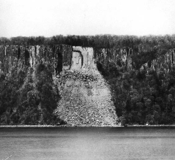
Photo courtesy of NJ Palisades website
The NJ Palisades is a stretch of forest going from the George Washington Bridge up north into NY state. It faced destruction at the hands of a rock quarry that was breaking down the sides of the cliffs to build roads in NYC. It was the destruction of a perceived profile of George Washington on the cliffs that spurred protests which closed the quarrying down in 1900.
A second profile can still be seen today, an Indian, near the Giant Stairs (a long & difficult section along the river’s edge.)
A third profile was more disturbing. A rock slide occurred on one of the cliff faces in July 1939. A Yonkers Ferry crew noticed that the rock face now bore a resemblance to Adolph Hitler. Was this just paranoia due to our involvement in WWII? The profile was 160 feet high and 50 feet wide. We’ll never know because on March 15, 1947, another rock slide obliterated this cliff face, 2 years after the defeat of Hitler by the Allied Forces.
7 Mar
the tunnels of the NJ Palisades
Related Pages:
My experience in the NJ Palisades
Manuel Rionda’s Stone Tower: A large medieval looking tower which was part of an estate that stretched to the edge of the Palisades Cliffs
Old Bridge: In the woods of Creskill is a large stone bridge, which may be a part of the old Camp Merritt. A bit of research and a few emails from readers suggests this bridge is more likely a relic from the Rionda estate…..
Hitler’s Rock Profile: A 160 ft tall profile of Hitler appeared on the cliffs of the Palisades during WWII
Complete history of the Palisades: A detailed summary of the history of the Palisades.
In an old cemetery in the Palisades is the grave of a fellow named “Whack me Jug”
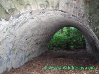
I recently explored some tunnels in the Palisades that a friend of mine had scoped out….These two are of a sewer that goes udnerneath 9W, alllowing a stream to get past the highway…


